[maxlat=57.0;minlat=52.0;maxlon=0;minlon=-3;maptype=G_SATELLITE_MAP;zoom=6]
- Coordinates: N 55°51’56, W 3°12’25.4
- Height: X 5m tower
- Base level: 193 m ASL
- Country: Scotland
- InGOS observations: CH4, N2O
- Responsible partner: CEH
- Responsible PI: Eico Nemitz(en@ceh.ac.uk)
- Access request pageTNA access request page for Easter Bush
- Website:http://www.ceh.ac.uk/sci_programmes/INGOS.html
General
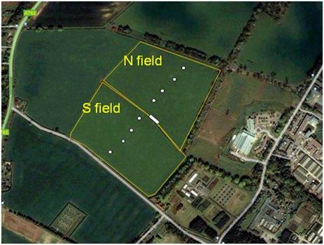
Easter Bush has been a key site of GREENGRASS, a validation site under the CarboEurope IP and a Level-3 site of NitroEurope IP. Instrumentation is located on the boundary of two fields that generally receive the same management, with the wind coming from the S field for 80% of the time. The site is conveniently located within walking distance to CEH’s Edinburgh laboratory and a range of ongoing measurements and excellent site infrastructure (100A of mains power, broadband connection) is available.
Ingos Activities at Easter Bush
The following activities are planned at Easter Bush during InGOS:
•N2O fluxes will be measured continuously with a state-of-the-art continuous wave quantum cascade laser absorption spectrometer (Aerodyne mini CW-QCL) from Feb 2012 to Feb 2013, providing an extended possibility to intercompare instrumentation.
•The South field will be ploughed up and reseeded in February/March 2012 for the first time after 25 years. This event provides an excellent opportunity to study the effect of this management on greenhouse gas emissions. Groups wishing to contribute should contact Ute Skiba or Eiko Nemitz.
•Easter Bush will host the N2O flux intercomparison campaign. Read more here: N2O Campaign
References for Easter Bush observations