[maxlat=58.0;minlat=55.0;maxlon=0;minlon=-4;maptype=G_SATELLITE_MAP;zoom=6]
- Coordinates: N 56.5551, W 2.9858
- Height: 230 m tower
- Base level: 400 m ASL
- Country: Scotland
- InGOS observations: CH4, N2O,SF6,Radon
- Responsible partner: UEDIN
- Responsible PI: (j.moncrieff@ed.ac.uk)
- TNA access request page for GGLES
- Website:http://www.metoffice.gov.uk/atmospheric-trends/sites/angus
General
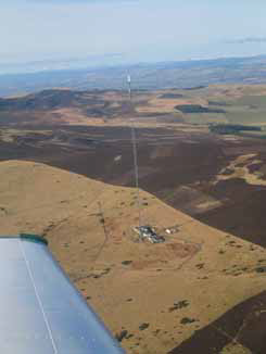
TTA is located on the east coast of Central Scotland, 8 km to the north-west of Dundee. The tower is a combined TV/radio broadcast mast owned and operated by Arqiva in the UK. The tower is 313 m asl on the Sidlaw Hills and the tower has two intake lines (at 50 m agl for radon 222; at 222 m agl for intake of greenhouse gases). The site was established as part of the CHIOTTO project with first measurements in 2005. Measurements have been continuous since and the site was part of the IMECC programme. Instrumentation at the site includes Hp/Agilent Gas Chromatographs for CH4, N2O and SF6; an RGA3 GC for H2 and CO; a Li-7000 IRGA for CO2. A Picarro Quantum Cascade Laser will be installed by the end of 2010 for atmospheric CO2 and CH4 concentration measurements in association with NERC CEH (Bush). Air temperature, atmospheric humidity and atmospheric pressure are recorded at 3 levels on the tower and also at ground level; wind speed and direction are recorded at 4 m agl at the base of the tower. A broadband connection at the site permits on-line retrieval of the data. Footprint analysis shows that TTA samples most of its signal from north Britain; about 85% of the signal comes from the relatively unpolluted areas to the west and north-west of the site. Research at the site involves PhD students examining source attribution and boundary-layer modelling. Data from TTA is used by met offices in the UK and Norway. TTA is also a site where boundary-layer profiling of greenhouse gases is centered using UEDIN’s research aircraft. TTA will be a target site for the new DIAL system.
Access
Collaborators at TTA will operate with UEDIN through the contact points of Prof. John Moncrieff and Robert Howard. Travel to and frAccessom the site is monitored by the operator to ensure safety at the site and visitors must be accompanied at all times. Access will be provided to the existing analysis infrastructure at TTA and help will be provided installing visitors equipment and integrating it into the existing system.
Tall Tower Angus has been used in CHIOTTO and IMECC projects and data is available from the databases of both these earlier projects. We have a website describing some of the work at TTA (http://www.geos.ed.ac.uk/abs/research/micromet/) and we are currently implementing a near real-time display of data from the tower (in addition to the NRT results available via IMECC). Data from TTA is being used in a number of ‘geoscience outreach’ projects targeting members of the general public and schoolchildren; this sort of outreach will increase in future. A number of popular radio programmes done by the BBC have featured TTA (e.g. (http://www.bbc.co.uk/programmes/b00t4q11) and the science surrounding it; posters and presentations continue to be delivered to scientific and non-scientific audiences (e.g. http://planetearth.nerc.ac.uk/multimedia/story.aspx?id=776). Data is also used in research projects in European Met Offices in the UK and Norway.