
Summary
- Coordinates: 48°23″ N, 1°22″ E
- Height: 213 m
- Base level: 168 m ASL
- Country: France
- InGOS observations:
- Responsible partner: INRA
- Responsible PI: Catherine Hénault (catherine.henault@orleans.inra.fr)
- Request TNA: access request page
General
The OS² site is located in the valley of the Loir river (48°23 N, 1°11 E, elevation 202 m asl) about 30 km south-west of Chartres, France. The mean temperature is 10.6°C and mean rainfall of 600 mm. The OS² consisted in 10 km² of cultivated fields from commercial farms. All soils are characterized and the pedological map has been established. Soils on the plateau of the East part of OS² are Luvisol locally hydromorphic with clay contents comprised between 12 to 15 %. Soils of the gentle slopes could have stones as they lay on clay with flint. Soils of the west part of OS² are mainly loamy gleyic luvisol with clay contents comprised between 15 – 20 % or are colluvic Cambisol. Soils of the Loir Valley are alluvial with high clay contents (20 to 40 %), with a semi-permanent water table. The soil diversity in OS² is representative of the pedological footprint of the Trainou tower. Luvisol of OS² is representative of more than 600000 ha of cultivated soils in France.

Gleyic luvisol observed on the west part of OS²
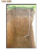
Luvisol on the plateau of the East part of OS²
A very large part of the soils of OS² are drained. Agricultural practices are informed from 2008. The typical crop succession is wheat/rapeseed/barley with fertilization around 200 kg N ha-1. Maïze, leguminous are also cultivated in this area. Grasslands are localised in the valley of the Loir river. Soils N2O emissions are measured in different plots since 2009 using the chamber method, testing the impact of soils’ properties on N2O fluxes. These plots are also equipped with TDR and temperature probes . The mineral nitrogen is periodically determined both in soils and in rivers as well as N2O emissions from the Loir river.
Infrastructure and facilities
- The site is electrified
- Visiting researchers will benefit from the ongoing measurements on soil and agricultural practices for interpreting their own measurements.
References for OS2 observations
- Gu, J., Nicoullaud, B., Rochette, P., Grossel, A., Hénault, C., Cellier, P., Richard, G. (2013). A regional experiment suggests that soil texture is a major control of N2O emissions from tile-drained winter wheat fields during the fertilization period. Soil Biology and Biochemistry, 60, 134-141. DOI : 101016/j.soilbio.2013.01.029. http://prodinra.inra.fr/record/194969
- Gu, J., Nicoullaud, B., Rochette, P., Pennock, D. J., Hénault, C., Cellier, P., Richard, G. (2011). Effect of topography on nitrous oxide emissions from winter wheat fields in Central France. Environmental Pollution, 159 (11), 3149-3155. DOI : 10.1016/j.envpol.2011.04.009. http://prodinra.inra.fr/record/42567
- Gu, J., Loustau, D., Hénault, C., Rochette, P., Cellier, P., Nicoullaud, B., Grossel, A., Richard, G. 2014. Modeling nitrous oxide emissions from tile-drained winter wheat fields in Central France, Nutrient Cycling in Agroecosystems, , vol 98(1), p27-40.
- Grossel A., Nicoullaud B., Bourennane H., Rochette P., Guimbaud C., Chartier M., Catoire V., Hénault C. 2014. Simulating the spatial variability of nitrous oxide emission from cropped soils at the within-field scale using the NOE model, Ecological modelling, vol 288, p155-166, 2014.